
In the Matter of
)
)
1998 Biennial Regulatory Review --
)
Amendment of Parts 2, 25 and 68 of the
)
Commission's Rules to Further Streamline
)
the Equipment Authorization Process for
)
Radio Frequency Equipment, Modify the
)
Equipment Authorization Process for
)
Telephone Terminal Equipment, Implement )
Mutual Recognition Agreements and Begin )
Implementation of the Global Mobile Personal ) GEN Docket No. 98-68
Communications by Satellite (GMPCS)
)
Arrangements
)
NOTICE OF PROPOSED RULE MAKING FCC 98-92
Adopted: May 14, 1998 Released: May 18, 1998
Items 44, 45 & Appendix A Item 5 of FCC-98-92 released May 18,1998 propose Global Mobile Personal Communications by Satellite (GMPCS) out of band emission limits that will likely prove inadequate for protecting GPS and GLONASS radionavigation systems from excessive desensitization. Specifically, the RTCA recommendation and NTIA recommendations are based on GPS receiver antenna gains being less than -10 dBiC in the direction of the GMPCS transmitter. While this may be a reasonable assumption for aircraft on final approach; there are many safety of life radionavigation applications where this is not the case; antenna gains of + 3dBi or higher are not unreasonable given the need to receive GPS/GLONASS signals from a plurality of directions to obtain a navigation solution. We would urge the commission to consider the full spectrum of safety of life applications rather than limit itself to a single "final approach" application before making a final ruling. Otherwise, GPS/GLONASS may be at risk of sudden and unexpected interruption in many safety of life applications.
Borrowing from the NPRM we recommend an additional 13 dB of protection
and verbiage to tie emission limits to radiated power. Item 5b in Appendix
A of the NPRM would read:
Secondly, we would note that both GPS and GLONASS use RHCP antennas.
These antennas generally afford significant rejection of Left Hand Circular
Polarized (LHCP) signals. Depending on axial ratios, there is at least 3
dB of rejection against LHCP and greater than 10dB of rejection is the norm.
If GMPCS uses LHCP, less stringent emission masks are needed. Given the space
based nature of GMPCS and MSS in general; there may be advantages in using
circular polarized antenna's as opposed to linear polarizations commonly
associated with ground mobile systems.
Example Safety of Life Applications That are Not Airborne
There are many safety of life applications beyond flight control. As
one example the FCC made a final ruling on Enhanced 911 (E911) services in:
Adopted: December 1, 1997 Released:
December 23, 1997
requiring:
GPS is one of the leading candidates for providing this required positioning capability to cellular telephony users.
Police, Fire, Medical Rescue services are all making extensive use of GPS to provide dispatch, rendezvous, and monitoring functions with safety of life implications. Disruptions in service to these users could lead to loss of life. The core question is: "Can proposed GMPCS emission limits lead to disruption of services and if so, what are more appropriate limits?" To address this question we need to look at GPS receiver sensitivities to interference.
Wideband Emissions Limits Analysis
GPS receivers determine location by measuring pseudorange to 4 (or more) GPS satellites to solve for position in x,y,z, and time. At the heart of the pseudorange measurement process are two tracking loops; the Phase Locked Loop (PLL) and the Delay Locked Loop (DLL). The PLL tracks GPS signal carrier phase and thus Doppler to a given satellite. It is also required to read 50 bps data telling the user where the satellite is. The DLL tracks GPS signal code phase and thus pseudorange to a given satellite.
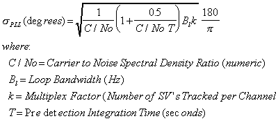
The PLL provides exquisitely accurate measurements of any changes in pseudorange but is unable to observe pseudorange directly because the L1 carrier (1575.42MHz) is ambiguous every 19 cm (1 wavelength). Just about every GPS receiver on the market uses this information to aid the DLL in what is commonly referred to as carrier aided code tracking. If the PLL looses lock on a given satellite, full accuracy tracking is lost. Thus, PLL tracking threshold is the defining point for loss of lock to a given satellite. Equation 1 shows PLL tracking jitter as a function of C/No for a Costas Loop of the type commonly found in GPS receivers.
 (Equation 1)
 Figure 1 plots this equation using a typical GPS PLL loop bandwidth of
17 Hz and a predetection integration time of 20 msec.
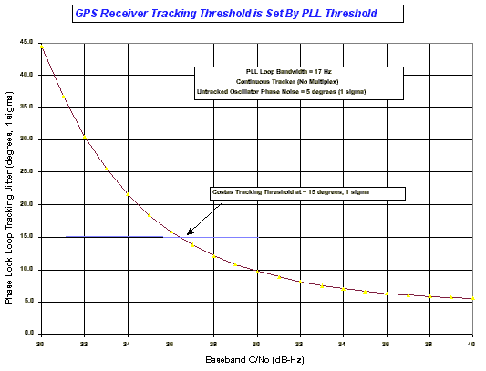
From this chart we can infer that a continuous tracking GPS receiver has reached its tracking threshold when baseband C/No reaches 26 dB-Hz. This corresponds to a tracking jitter of 15o (1s); much more and the PLL discriminator produces too many ambiguous phase error measurements and the tracking loop looses lock. Table 1 shows baseband C/No and associated tracking and acquisition margins for a low elevation satellite for three types of receiver: a multichannel continuous receiver, a 4 SV (Satellite Vehicle) Multiplex (MUX) receiver, and an 8 SV MUX receiver.
In Table 1 we've assumed a 1.5 dB Noise Figure typical of off the shelf
active antennas. The 2 dB implementation loss is characteristic receivers
using one bit A/D converters. Given that most GPS satellites are at low elevation
angles, a -4 dBiC antenna gain has been used in computing baseband C/No. This
make allowances for user tilt and antenna gain falloffs associated with reception
at lower elevation angles. With these assumptions; baseband C/No is at 36.4
dB-Hz when L1 C/A signal strength is at -130 dBm as specified in ICD-GPS-200C
(25 September 1997).
|
|
|||
| Number of SV's Tracked per Channel (Multiplex Factor): | 1.00 | 4.00 | 8.00 |
| Antenna Temperature (K): | 300.00 | 300.00 | 300.00 |
| GPS Receiver Noise Figure (dB @290K): | 1.50 | 1.50 | 1.50 |
| GPS Receiver Noise Temperature (K): | 119.64 | 119.64 | 119.64 |
| System Noise Temperature (K): | 419.64 | 419.64 | 419.64 |
| Total Thermal Noise Power (dBm/Hz): | -172.37 | -172.37 | -172.37 |
| GPS Signal Power (dBm): | -130.00 | -130.00 | -130.00 |
| Antenna Gain (dBiC): | -4.00 | -4.00 | -4.00 |
| Receiver Implementation Loss (dB): | 2.00 | 2.00 | 2.00 |
| Received Baseband C/No (dB-Hz): | 36.37 | 36.37 | 36.37 |
| Tracking Threshold (dB-Hz): | 26.00 | 32.02 | 35.03 |
| Tracking Margin (dB): | 10.37 | 4.35 | 1.34 |
| Acquisition Threshold (dB-Hz): | 30.00 | 36.02 | 39.03 |
| Acquisition Margin (dB): | 6.37 | 0.35 | -2.66 |
In the case of a continuous tracking multichannel receiver we see a tracking
threshold margin of 10.4 dB and an acquisition margin of 6.4 dB. When we consider
multiplexing receivers, margins drop by 10 log10 (4) = 6 dB for the 4 channel
multiplex receiver and 10 log10 (8) = 9 dB for the 8 channel multiplex receiver.
It is unlikely the 8 SV MUX receiver could acquire under these conditions
and would have to use higher elevation satellites with attendant degradation
in navigation accuracy because of worsened HDOP (Horizontal Dilution Of Precision)
and PDOP (Position Dilution Of Precision). From Table I we can infer that
GPS receivers do not necessarily operate with a great deal of link margin;
particularly multiplex receivers.
We now come to the question of how much GMPCS out of band emissions desensitize
GPS receivers. Table 2 shows thermal noise power spectral density coming out
of the GPS receiver preamplifier referenced to the input assuming a 1.5 dB
Noise Figure and a 300K antenna temperature characteristic of the "omnidirectional"
GPS antennas used in user equipment.
| Antenna Temperature (K): | 300 |
| GPS Receiver Noise Figure (dB @290K): | 1.5 |
| GPS Receiver Noise Temperature (K): | 119.6358879 |
| System Noise Temperature (K): | 419.6358879 |
| Total Thermal Noise Power (dBm/MHz): | -112.3724829 |
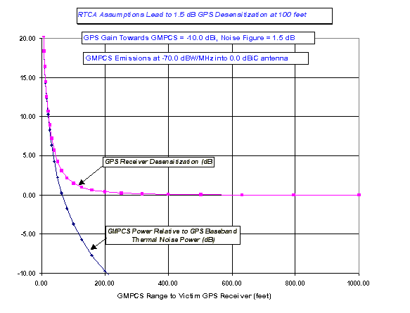
Assuming free space propagation from the GMPCS transmitter to the victim
GPS receiver we obtain the results of figure 2 under the RTCA assumption of
-10 dBiC GPS gain in the direction of the GMPCS transmitter. Desensitization
is computed as:
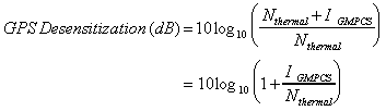 (Equation 2)
 Close examination shows 1.5 dB of desensitization at 100 feet which seems
reasonable.
Now consider a more typical antenna for ground mobile GPS applications.
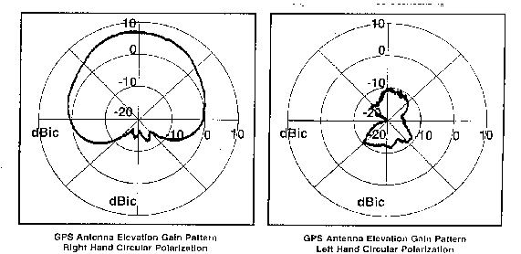
Figure 3 shows RHCP & LHCP elevation cuts for a typical L1 only GPS antenna.
It has 0 dBiC (RHCP) gain at the horizon and about +3 dBiC (RHCP) gain at
30o elevation. Using a +3 dBiC (RHCP) gain toward the GMPCS transmitter
to account for roll, we now obtain the results of Figure 4. Now we see almost
10dB of GPS receiver desensitization at 100 feet. The results of Table 1,
show that just about every class of GPS receiver would be in serious trouble
with this level of desensitization. This would be particularly true if there
are other propagation impairments such as foliage attenuation and/or building
penetration losses.
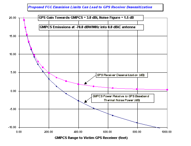
We argue that the use of a 100 foot range is even more appropriate in ground mobile safety of life applications where there is a high probability that GMPCS earth terminal could get within 100 feet of a GPS receiver. Imagine the police officer who calls for backup and expects GPS to automatically provide a position fix but there is a GMPCS user across the street talking to a phone solicitor.
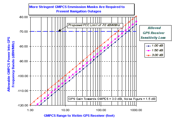
Again using free space propagation models, Figure 5 shows allowable GMPCS
emission limits as a function of range to maintain desensitization protection
levels of 1, 1.5 and 3 dB.
Narrowband Emissions Limits Analysis
Regarding narrowband emission limits, the NPRM is not specific on narrowband GMPCS emission bandwidths; it simply states a measurement bandwidth of 700 Hz. Narrowband GMPCS out of band emissions may actually be CW if they are synthesizer spurs or they may be modulation artifacts having somewhat wider bandwidths. There may be multiple spurs occurring within the GPS/GLONASS frequency band.
CW interference can be particularly damaging for C/A code receivers because of the C/A code's line spectrum structure. Military P(Y) receivers use a long period code and have no particular susceptibility towards CW jamming.
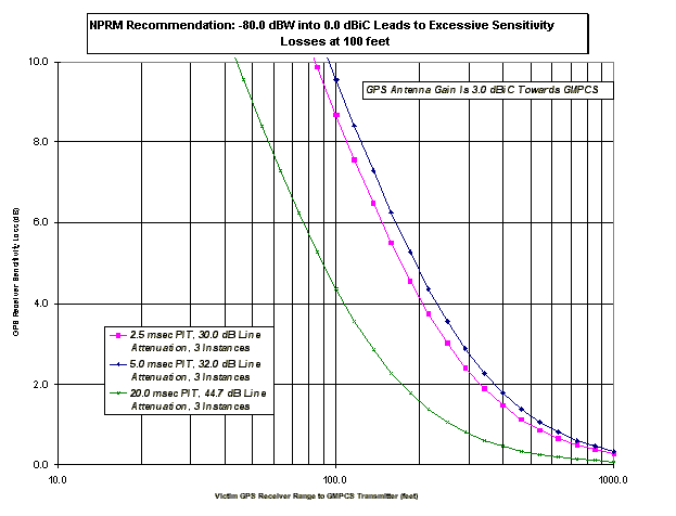
The C/A code has a line spectrum structure because of its short length (1023 chips). Figure 6 shows the line spectrum properties of C/A code PRN#1 which is typical of all of the codes. A C/A code period of 1 msec results in lines spaced 1 kHz apart. While most of the line components are small with respect to (wrt) the total GPS signal energy, there is a small fraction of powerful line components. Figure 6 shows 96% of the lines are below -25 dB wrt total energy and 66% are below -30 dB wrt total energy .
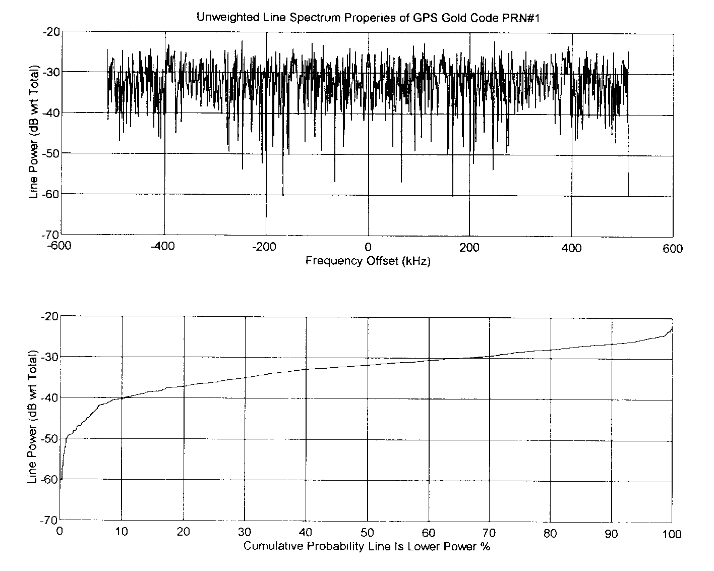
The significance of these lines is that if a C/A code receiver gets hit by a CW jammer at a big line's frequency offset, the GPS receiver doesn't show full processing gain against the interfering source. Instead, the jammer is attenuated only by the magnitude of the line plus attenuation due to baseband filtering prior to the PLL discriminator. The PLL may then lock onto the resultant baseband CW signal if it is strong enough but in well designed GPS receivers appropriate tests make sure the set is truly locked onto a GPS signal. Nonetheless, jamming energy can disrupt tracking and lead to a loss of navigation.
Baseband filtering significantly alters CW jammer sensitivities by providing
additional attenuation beyond that provided by the C/A code. Predetection
integration times of 20 msec are typical in continuous tracking GPS receivers.
This corresponds to a predetection equivalent noise bandwidth of 1/(.020 sec)=50
Hz. Four SV MUX receivers typically use a 20 msec / 4 = 5 msec Predetection
Integration Time (PIT) and 8 SV MUX receivers use a 20 msec / 8 = 2.5 msec
PIT. The specific filter response is given by:
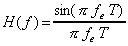 where T is predetection integration time & fe is frequency
offset
where T is predetection integration time & fe is frequency
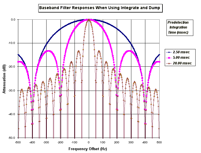
offset Figure 7 plots this filter's power response. A strong line response showing up at 100 Hz frequency offset from center frequency would be strongly attenuated if we are using a 20 msec PIT but would only be attenuated by 0.9 dB if we use a 2.5 msec PIT.
Figure 8 shows Cumulative CW Jammer Post Code Mixing Attenuation Levels for PRN#1 accounting for the attenuation due to predetection integration in the GPS receiver. Note that GPS receivers using longer predetection integration times tend to attenuate line jammers more strongly on a statistical basis. This is because the narrower filter response presents a more difficult target. With a 20 msec PIT, strongest responses occur when the CW jammer gets translated via the C/A code mixing process to within + 25Hz of the desire GPS signal's center frequency. With a 2.5 msec PIT, the corresponding range is + 200 Hz.
Table 3 shows attenuation values for confidence levels of 50% and 90%.
|
|
|
|
|
|
|
|
|
|
|
|
|
|
|
|
We now come to the question of GPS receiver desensitization. Table 4
computes thermal noise out of the preamplifier referenced to the input for
predetection integration times of 20, 5, & 2.5 msec and computes total
noise in the associated baseband equivalent noise bandwidth via:
 (Equation 3)
 where:
This is the amount of thermal noise seen at the input to the PLL discriminator.
| Predetection Integration Time (msec): | 20.00 | 5.00 | 2.50 |
| Baseband Equivalent Noise Bandwidth(Hz): | 50.00 | 200.00 | 400.00 |
| Antenna Temperature (K): | 300.00 | 300.00 | 300.00 |
| GPS Receiver Noise Figure (dB @290K): | 1.50 | 1.50 | 1.50 |
| GPS Receiver Noise Temperature (K): | 119.64 | 119.64 | 119.64 |
| System Noise Temperature (K): | 419.64 | 419.64 | 419.64 |
| Total Thermal Noise Power (dBm/Hz): | -172.37 | -172.37 | -172.37 |
| Thermal Noise Power In Reference Bandwidth (dBm): | -155.38 | -149.36 | -146.35 |
To compute jammer power out of the predetection integration process we use
the equation:
 (Equation 4)
 where:
Once again, this is the amount of GMPCS interference that is seen at
the input to the PLL discriminator. Equations 4 & 5 can then be used
to compute GPS receiver desensitization via equation 2. Justification for
using only a 90% confidence level is that each C/A code has a different line
structure and CW jamming that is problematic for one SV may have little effect
on another. If one SV gets jammed out, there may be another that can be used
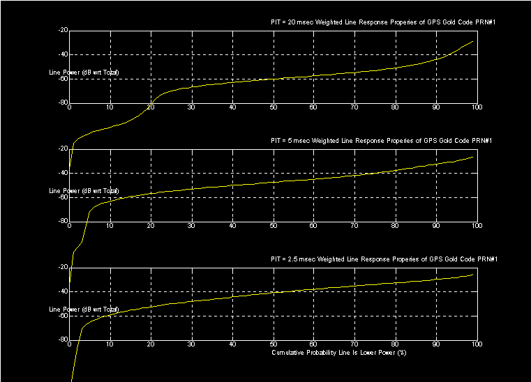
with only a little degradation in Dilution Of Position (DOP). Figure 9 shows
GPS receiver desensitization as a function of range using the NPRM narrowband
limits assuming that GMPCS interference is CW and that there are three equal
power spurs in the GPS frequency band. Again, the GPS receiver's antenna
gain toward the GMPCS terminal is 3 dBi.
We see that the Multiplex receivers (5 and 2.5 msec PIT) are most sensitive to narrowband jamming but that all receiver types show significant desensitization at 100 feet. Referring back to Table 1; the Multiplex receivers are also they type most vulnerable to desensitization.
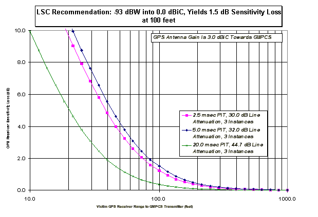
Figure 10 shows results using the recommended level of -93 dBW/700 Hz
EIRP. Now, desensitization is limited to 1.5 dB or less for all receiver
types.
Conclusions and Closing Remarks
The above analysis has shown NPRM protection levels for radionavigation systems to be inadequate. The bottom line is that NPRM protections were derived for avionics applications where a -10 dBi GPS receiver antenna gain towards the GMPCS terminal is reasonable. In other safety of life applications GPS antenna gains can easily be 13 dB higher (+3dBi gain). As a consequence, GMPCS emission limits need to be tightened an additional 13 dB to the recommended values.
Finally, we would like to reemphasize that GMPCS emission limits can
be relaxed considerably by requiring GMPCS to use Left Hand Circular Polarization.
This would appear to benefit GMPCS independent of radionavigation questions
because the wide range of GMPCS Satellite to Earth Terminal orientations
favors the use of circular polarizations over linear polarizations anyways.
LSC, Inc.
By:__________________________
Logan Scott, Principal
P.O.Box 4734
Breckenridge, CO 80424
loganscott53@earthlink.net
http://ourworld.compuserve.com/homepages/loganscott/LSChome.htm
Dated: June 24, 1998
End notes (These are the footnotes in the Comment Submitted to the FCC):
For example, see figure 3 in this document.
Frequency Locked Loops can extend threshold tracking performance an additional 3 to 5 dB but during this mode of operation, navigation accuracy degrades and 50 bps data is not easily read.
Other types of discriminators such as sign(I)*Q and ATAN2(Q,I) show similar performance.
Loop bandwidth requirements are set by user equipment dynamics.
An SV is a GPS satellite.
50% of GPS satellites are found at elevations between 0o and 30o above the horizon. GPS receivers typically limit themselves to using only satellites above 5o because of undesirable signal propagation effects at lower elevation angles.
RTCA recommendations place acquisition threshold 6 dB above tracking threshold but our experience is that 4 dB is adequate.
Horizontal location (east/north) is derived primarily from low elevation satellites while vertical (up) positioning is derived primarily from higher elevation angle satellites.
To see a specification sheet showing receiver tracking threshold of 34 dB-Hz; look at http://www.marconi.ca/Docs/CMC/Aerospace/cma3112.html
At L1 frequency (1575.42 MHz), free space path loss is PL (dB) = 96.4 + 20 Log10 R where R is in km
In the military arena, Combat Survivor / Evader Locator (CSEL) provides this capability in the form of a 28 oz. unit that combines a UHF radio with a GPS to automatically report position. Police will likely carry similar units in the near future.
GPS is a Code Division Multiple Access (CDMA) system with each SV broadcasting a distinct code. GPS and WAAS C/A codes are all members of a single Gold code family.
Often referred to as arm filters.
Each GPS signal has a distinct center frequency within about + 5kHz of 1575.42 MHz because of Doppler and receiver oscillator effects.
Rather than allow an unlimited number of spurs within the radionavigation
band we suggest limiting he number and specifying it. Otherwise the emission
limits per spur will need to be tightened